-
 Severe Midwest weather, including a tornado, leaves at least 14 dead in Kentucky; 7 dead in MissouriAs of Saturday morning, some 14 people in Kentucky have been killed by severe weather — including a devastating tornado — and the death toll is likely to rise, according to Gov. Andy Beshear.
 -
 Intense winds, including suspected tornadoes, ripped through east Louisville and several western Kentucky counties Wednesday night. Gov. Andy Beshear said no fatalities have been reported, but noted injuries and structural damage.
 -
 Dozens of homes were destroyed in the town of Milton, Kentucky, after a tornado hit Thursday afternoon.
 -
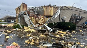
Severe storms with suspected tornadoes have damaged homes and businesses and killed at least three people in the central United States.
-
 Deadly tornadoes tore through Middle Tennessee on Saturday, causing damage and power outages for thousands. As of 7:15 p.m., six people were confirmed dead. There were three deaths in Clarksville and three in the Madison area of Nashville. There were also dozens of injuries across the region.
 -
The National Weather Service office in Paducah confirmed that two E-F 1 tornadoes touched down in the Purchase Area on Saturday morning.
-
The results of a National Weather Service damage survey confirmed that an EF-1 tornado touched down in Graves, Marshall and Lyon counties as a severe storm cut across western Kentucky this past weekend.
-
 Gov. Andy Beshear warned of severe weather predicted to hit the western portion of Kentucky on Friday, with the Jackson Purchase Area in “significant danger” for severe weather, including possible tornadoes, on Friday night.
 -
 Volunteers and residents are still clearing debris in far western Kentucky, where an EF-2 tornado impacted a small McCracken County community as a deadly band of storms left hundreds of thousands of Kentuckians without power earlier this month.
 -
 A Mayfield group focused on the community’s recovery from the deadly and historic tornado outbreak that impacted the region last year hit a big milestone Monday, giving its first newly renovated home to an unhoused survivor.

© 2026
News and Music Discovery
Play Live Radio
Next Up:
0:00
0:00
Available On Air Stations


